Company Profile
Key Services
CV Geospatial offers its services to clients with interests on
leveraging their internal GIS capabilities. We cater to companies and
offices with concerns with urban planning, environmental management,
transporation, tourism, real estate, agriculture, forestry, and
disaster management.
- Spatial Data Analysis
- This service is to provide spatial data analysis for location-specific problems and solutions. It includes analyzing spatial data to uncover patterns and trends and is applied in industries such as urban planning, environmental management, and transportation.
- Mapping and Visualization
- This service offers mapping and visualization of data acquired in the field and remote sensing images. The objective is to create custom maps and visualizations for better information dissemination and communication. The maps provided are a result of appropriate geoprocessing and remote sensing tools and analysis and maybe visualized through map figures, web-based applications and local hosts.
- Geocoding Services
- The geocoding service offers converting non-spatial locational data such as addresses into its corresponding geographic coordinates and spatial representation for proper mapping and analysis. The result of this service may be visualized through map figures and web-based applications.
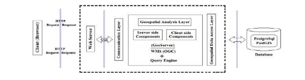
- Geospatial Data Management
- This service is to provide Geographic Information System solutions tailored to client needs. It covers storing, managing, and sharing geospatial data securely. It includes activities such as data transformation, database management systems creation and/or integration. Integration of systems involve existing databases and web-based mapping systems. Below shows a general three-tier web GIS architecture sample that this service offers.
- Training and Support
- This service offers training sessions and ongoing support for GIS software and tools. Training involves theoretical, objective and hands-on approaches to efficiently provide and enhance users the capacity in the use of GIS in a professional setting.
- Consulting Services
-
This service aims to provide expert advice on GIS implementation
and strategy. It includes planning, requirement analysis,
spatial data modelling, design acquisition and development. This
service may be in conjunction with geospatial data management
systems integration and/or creation.
Sample Demo - Parcellary Tax Web Visualization Map
Projects
verified
GIS Database administration : creation of open layer system
visualization of tax map- parcellary lot of ibaan, batangas with
security and GUI
verified
Consulting services for metro la union public transport
pre-investment study under dotr
verified
Georeferencing of satellite imagery in mining geomatics survey group
in nepal
verified
Hydrological Analysis of Post and Pre Panaytayon-Agusan del Sur and
Muntinlupa City using HEC-RAS hydrologic software - the projects are
for the comparison of flood maps regarding the post and pre-
rechanneling of the Panaytayon River
verified
Hydrological Analysis of Muntinlupa City using HEC-RAS hydrologic
software - the projects are for the creation of depth flood maps 15,
25 and 50 years and the increasing urbanization of Alabang,
Muntinlupa City
verified
Mapping of Land Use Land Class (LULC) using multi-temporal
satellite, using Google Earth Engine (GEE) with Java code and
Quantum Geographical Information System (QGIS) of Agusan del Sur –
the project is for the land use. The data used for the project is
acquired from the Landsat 8 and Sentinel 2 and was geometrically
corrected and analyzed using Google Earth Engine and QGIS
Application.
verified
Mapping of identified Trees, under Department of Public Works
Highways (DPWH) under Metro Manila using Civil 3D
verified
Mapping of Groundwater Inventory, Geologic Map, Surface Water, and
Digital Elevation of Manicani Island Samar for Environmental Study
CONTACT US
person
Honeylyn A. Carpio
BS Agriculturist
MS Geomatics Engineering
+63-967-491-8529
person
Patricia Natividad M. Verano
BS Geology
MS Geomatics Engineering
+63-945-350-4480
location_city
Quezon City, Philippines
olivinec.gis@gmail.com